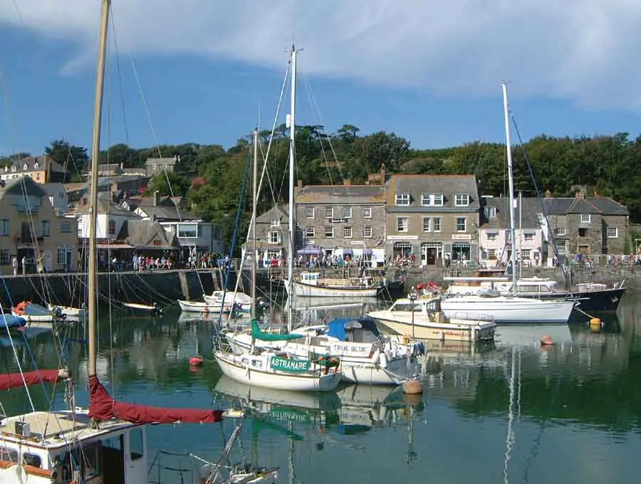
Padstow is a town, civil parish and fishing port on the west bank of the River Camel estuary, on the north coast of Cornwall. The parish held 2,669 people at the 2021 census and the built-up area 2,298: a small town rather than a village, taking in Trevone too.
You go from Newquay for the harbour: a working one, fishing boats and commercial vessels alongside yachts, sitting in the middle of the town rather than at its edge. It is also the end of the Camel Trail, so much of the daily crowd arrives by bicycle. And it is an eating town — Rick Stein’s restaurants and cafés pull people from long distances, enough that food writers took to calling the place “Padstein”.
The straight-line distance is 17.0 km.
The outer harbour is tidal and takes ships and commercial vessels; the inner one is a half-tide dock whose “gate-flap” holds water back on an ebbing tide, so the yachts inside stay afloat at every state of the tide. Padstow Harbour carries 4.6 from 3,994 Google reviews.
Two practical points recur. It is not cheap: a visitor in May 2026 advised, “if you’re going down to Cornwall/Devon, save some extra cash, because it is expensive”. And the middle of town is the wrong place to expect a parking space. A visitor in November 2024 wrote, “Parking in the heart of the marina is limited, and a few spaces are allocated for disabled people. Since it is a popular destination, I recommend visiting early in the day,” and added that “Some streets are cobbled, which may be uncomfortable for visitors in wheelchairs”.
The Black Tor Ferry carries foot passengers between Padstow and Rock daily all year, and wildlife boat trips run from the quay — Padstow Sealife Safaris, 4.8 from 614 Google reviews.
Trevone Bay, in the same parish, is the substantial beach. It holds 4.7 from 903 Google reviews, and a visitor in August 2026 described “a blue flag beach with attentive lifeguards and slightly sloping, clean sands. The tide goes out a long way so you may have a bit of a walk to get to the water at times”. A visitor in May 2026 recorded lagoons and a stream for small children, a natural pool ten minutes along the coast, and “Lifeguard always on site. Paid toilet.” One more, in June 2026, is a warning: “Just watch for undercurrents to the right of the bay.”
Nearer the town, Hawker’s Cove holds 4.8 from 279 Google reviews and St George’s Cove 4.8 from 273: high scores on small samples.
West of the town the geology shows: Tregudda Gorge, cut by erosion along a faultline into sheer cliffs; the Marble Cliffs, with alternating dark and light grey strata; and the Round Hole, a collapsed sea cave.
The indoor option is the National Lobster Hatchery, 4.5 from 1,139 Google reviews and “a brilliant little museum just the right size to spend an hour or two” to a visitor in August 2026.
The approach into the Camel is partially blocked by the Doom Bar, a bank of sand across the estuary that has caused many wrecks. Ships entering lost the wind under the cliffs and were swept onto it; a capstan on the west bank, its remains still visible, and rockets fired to carry a line out let vessels be winched clear. A lifeboat station followed in 1827.
The town was Adelstow, after Æthelstan, before it became Petroc-stow for the Welsh missionary Saint Petroc, who landed at Trebetherick around AD 500. The monastery founded here was raided by the Vikings in 981, and the monks moved inland to Bodmin with the saint’s relics; Domesday recorded the manor in 1086 as held by Bodmin Monastery.
Being one of very few safe havens on the north coast made it a busy port: trade with Ireland and the Bristol Channel, tin, copper, lead, slate, cured fish and dairy produce out, timber, salt, wine, hemp, iron and jute in. In the first half of the 19th century it was a significant port of embarkation for emigrants bound for Canada; five shipyards were working late in the century, declining by 1900.
The ‘Obby ‘Oss festival begins at midnight on May Eve, when townspeople gather outside the Golden Lion Inn to sing the “Night Song”; by morning the streets are dressed with greenery and flowers set around the maypole. Two ‘Obby ‘Osses, the “Old” and the “Blue Ribbon”, are then danced through the town by masked men in black frame-hung capes, prodded on by “Teasers”, until late in the evening the two meet at the maypole.
The midwinter custom is more difficult. On Boxing Day and New Year’s Day some residents black up and parade singing ‘minstrel’ songs. Folklorists tie it to the British custom of blacking up for mumming and morris dancing, and it has been renamed Mummers’ Day, but protests resurface annually.
By bus, service 56 runs from Newquay to Padstow, operated by Go Cornwall Bus, mostly hourly Monday to Saturday and less often on Sundays and Bank Holidays.
There is no station: Padstow’s opened in 1899 as the westernmost point of what became the Southern Railway and closed in 1967. The nearest is Bodmin Parkway, three miles southeast of Bodmin, reachable by Go Cornwall Bus.
The line became the Camel Trail, 17.3 miles (27.8 km) from Padstow to Wadebridge and on to Bodmin, open to walkers, cyclists and horse riders, suitable for disabled access and used by an estimated 400,000 people a year. From Newquay the popular ride is the Wadebridge and Padstow loop, 45.8 miles (73.8 km) and about five hours. Hire is at the Padstow end, because Newquay itself has none: Trail Bike Hire Padstow and Padstow Cycle Hire, both on South Quay. A visitor in June 2026 noted you “Can rent bikes here to cycle along the Camel Bike Trail.”
Driving, Padstow Town Car Park on South Quay is the weakest-rated place named here, 4.2 from 790 Google reviews. On foot, the South West Coast Path runs along both sides of the estuary and crosses to Rock by the Black Tor ferry, putting Stepper Point and Trevose Head within an easy day’s walk; the Saints’ Way starts here and runs to Fowey on the south coast.
The village and what is around it, at walking scale.
Open any of them in Google Maps for directions and current opening.
Attractions, prices and availability in Newquay
These come from GetYourGuide's booking widget, which sets their cookies in your browser. Consent to load it and see the attractions and prices.
Background on Padstow draws on its Wikipedia article, text there being available under CC BY-SA 4.0.